- Original Caption Released with Image:
-
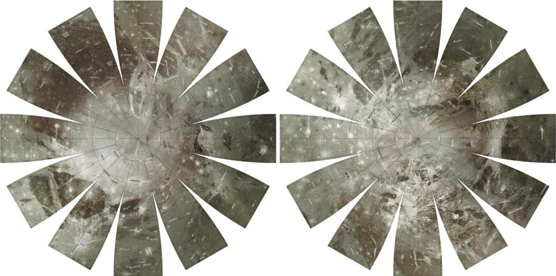
The images used for the base of this Ganymede globe were chosen from coverage supplied by the Galileo solid-state imaging (SSI) camera and Voyager 1 and 2 spacecraft. The monochrome and color data were both processed using Integrated Software for Imagers and Spectrometers (ISIS). The individual images were radiometrically calibrated and photometrically normalized using a Lunar-Lambert function with empirically derived values. A linear correction based on the statistics of all overlapping areas was then applied to minimize image brightness variations. The image data were selected on the basis of overall image quality, reasonable original input resolution (from 20 km/pixel for gap fill to as much as 180 m/pixel), and availability of moderate emission/incidence angles for topography and albedo. The black and white monochrome base mosaic was constructed separately from the three-band color mosaic. Although consistency was achieved where possible, different filters were included for monochrome global image coverage as necessary: clear for Voyager 1 and 2; clear, near-IR (757 nm), and green (559 nm) for Galileo SSI. Individual images were projected to a Sinusoidal Equal-Area projection at an image resolution of 1 km/pixel. The global color mosaic was processed in Sinusoidal projection with an image resolution of 6 km/pixel. The color utilized the SSI filters 1-micron (991 nm) wavelength for red, SSI 559 nm for green, and SSI 413 nm for violet. Where SSI color coverage was lacking in the longitude range of 210°-250°, Voyager 2 wide-angle images were included to complete the global coverage. The chosen filters for the Voyager 2 data were ~530 nm for green, and ~480-500 nm for blue. The red band was synthesized in this area based on statistics calculated from the surrounding SSI 1-micron (991 nm) data and SSI and Voyager data in the blue and green bands. The final global color mosaic was then scaled up to 1 km/pixel and merged with the monochrome mosaic. The north pole and south pole regions that lack digital color coverage have been completed with the monochrome map coverage. The final global mosaic was then reprojected so that the entire surface of Ganymede is portrayed in a manner suitable for the production of a globe. A specialized program was used to create the "flower petal" appearance of the images; the area of each petal from 0 to 75 degrees latitude is in the Transverse Mercator projection, and the area from 75 to 90 degrees latitude is in the Lambert Azimuthal Equal-Area projection. The projections for adjacent petals overlap by 2 degrees of longitude, so that some features are shown twice. Names shown on the globe are approved by the International Astronomical Union. The number, size, and placement of text were chosen for a 9-inch globe. A complete list of Ganymede nomenclature can be found at the Gazetteer of Planetary Nomenclature at http://planetarynames.wr.usgs.gov. The northern hemisphere is shown on the left, and the southern hemisphere is shown on the right.
- Image Credit:
-
NASA/JPL/USGS
Image Addition Date: -
2002-05-10
|
 Planetary Data System


