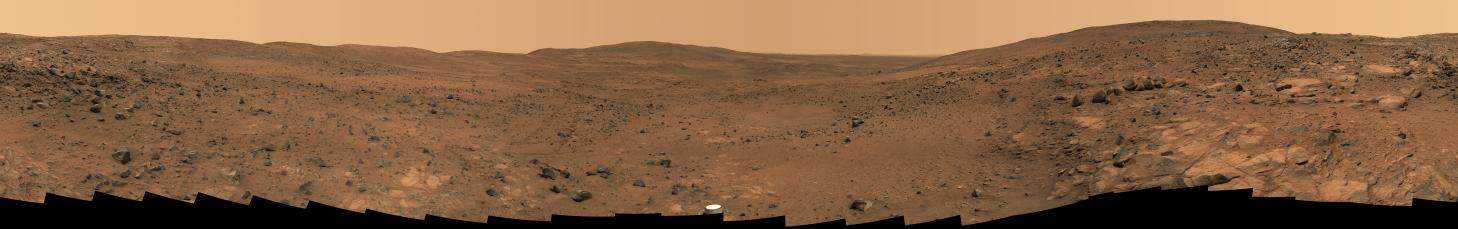
Click on the image for Descent from the Summit of 'Husband Hill' (QTVR)In late November 2005 while descending "Husband Hill," NASA's Mars Exploration Rover Spirit took the most detailed panorama so far of the "Inner Basin," the rover's next target destination. Spirit acquired the 405 individual images that make up this 360-degree view of the surrounding terrain using five different filters on the panoramic camera. The rover took the images on Martian days, or sols, 672 to 677 (Nov. 23 to 28, 2005 -- the Thanksgiving holiday weekend).
This image is an approximately true-color rendering using camera's 750-, 530-, and 430-nanometer filters. Seams between individual frames have been eliminated from the sky portion of the mosaic to better simulate the vista a person standing on Mars would see.
"Home Plate," a bright, semi-circular feature scientists hope to investigate, is harder to discern in this image than in earlier views taken from higher up the hill. Spirit acquired this more oblique view, known as the "Seminole panorama," from about halfway down the south flank of Husband Hill, 50 meters (164 feet) or so below the summit. Near the center of the panorama, on the horizon, are "McCool Hill" and "Ramon Hill," named, like Husband Hill, in honor of the fallen astronauts of the space shuttle Columbia. Husband Hill is visible behind the rover, on the right and left sides of the panorama. An arc of rover tracks made while avoiding obstacles and getting into position to examine rock outcrops can be traced over a long distance by zooming in to explore the panorama in greater detail.
Spirit is now significantly farther downhill toward the center of this panorama, en route to Home Plate and other enigmatic soils and outcrop rocks in the quest to uncover the history of Gusev Crater and the "Columbia Hills."