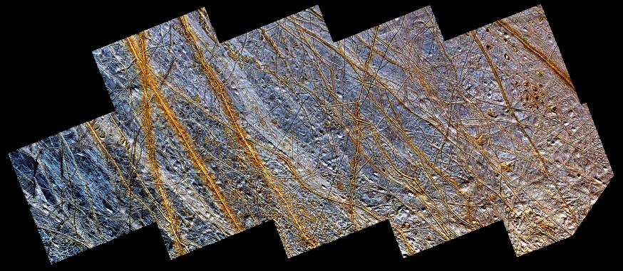
This mosaic of a region in the northern hemisphere of Jupiter's moon, Europa, displays many of the features which are typical on the satellite's icy surface. Brown, linear (double) ridges extend prominently across the scene. They could be frozen remnants of cryovolcanic activity which occurred when water or partly molten water ice erupted on the Europan surface, freezing almost instantly in the extremely low temperatures so far from our sun. Dark spots, several kilometers in diameter, are distributed over the surface. A geologically older, smoother surface, bluish in tone, underlies the ridge system. The blue surface is composed of almost pure water ice, whereas the composition of the dark, brownish spots and ridges is not certain. One possibility is that they contain evaporites such as mineral salts in a matrix of high water content.
North is to the lower left of the picture and the sun illuminates the surface from the upper left. The image, centered at 40 degrees north latitude and 225 degrees west longitude, covers an area approximately 800 by 350 kilometers (500 by 220 miles). The resolution is 230 meters (250 yards) per picture element. The colors have been enhanced to bring out the details. An astronaut orbiting this smallest of the four Galilean satellites would seethe icy surface of Europa somewhat brighter, but with less intense colors. The images were obtained during two separate orbits of Jupiter by the Solid State Imaging (SSI) system on NASA's Galileo spacecraft. High resolution images obtained at a range of about 25,000 kilometers (15,000 miles) during the spacecraft's 15th orbit of Jupiter on May 31st, 1998 are combined with lower resolution images obtained during the spacecraft's first orbit of Jupiter on June 28th, 1996. Combining the lower resolution and high resolution images enables scientists to investigate both the surface features in great detail as well as the color or compositional information in a regional context.
The Jet Propulsion Laboratory, Pasadena, CA manages the Galileo mission or NASA's Office of Space Science, Washington, DC.
This image and other images and data received from Galileo are posted on the World Wide Web, on the Galileo mission home page at URL http://solarsystem.nasa.gov/galileo/. Background information and educational context for the images can be found at URL http://www.jpl.nasa.gov/galileo/sepo
 Planetary Data System


